In my experiences of discussions relating to the case of Cussac in 1967, it occurred several times that when I discussed a particular point, it was argued that I should discuss some other point(s). I want to specify that what follows is neither a demonstration that the object allegedly seen was or was not an helicopter or an alien spaceship or whatever else, and that the following is not an act allegiance to any work or writings of anybody, neither a study of the exactitude of the distances between some stone wall and some UFO, neither an investigation into the case, nor a statement on the value or solidity of the case.
The items discussed here are in no manner a declaration infallibility of mine, they are not claimed to be "scientific", I never introduced myself as "a scientist" nor an "expert" about anything, I am not the puppet of anybody. I do not claim objectivity, I only claim I try to be. I will make note of any remark, correction, addition, comment, under the sine qua non condition that it contains no insults, nothing discourteous, nothing irrelevant, and no questioning of my intents.
The source of the claim that I discuss here is:
In this on-line preliminary version of their book, and perhaps also in its printed version, authors Eric Déguillaume, Eric Maillot, and David Rossoni, claim that the measurements deferred on "the" plans presented in the GEPAN investigation report on this alleged sighting are "incoherent."
As demonstration of this alleged inconsistency, they indicate that on three plans and sketches of the places in this report, the road is drawn rectilinear after the hedge, and that it would actually start a definite turn even before" the hedge.
They deduce from this that either the "position of the trace in the meadow" is false, or that the distance between the road and "the trace" is false, and thus consider that what is written higher is true, namely that the measurements deferred in the sketches and maps of the GEPAN are "incoherent".
It is this claim that I examine here.
This means that I an going to check all that is claimed there, explicitly or implicitly:
With this intention, the first step is make an inventory of the criticized data, i.e. the blamed "three plans and sketches" and the measurements written on those by the GEPAN.
The document containing the plans and measurements accused of inconsistency by the authors is the GEPAN investigation report:
In this report, the following maps and/or sketches appear:
This list is complete. The items concerned directly here are thus those of pages 7, 11, 13 and 25. I note that the authors declare that the road appears rectilinear on 3 plans and sketches and that the report contains 4 plans and sketches where the road appears, as well as two geographical maps showing the road. This results that at least one of the sketches seems "off topic", but one does not know which one, it is thus necessary to me thus to check all the four of them.
A difficulty is caused by the fact that the report published on the web obviously has a resolution quite lower than its original paper version, and that occasionally some captions are hardly readable. Nobody is to be blamed of that. The weak resolution of the version web was intended to result in a file not too long to download. The original sketches are by hand in black on white and the captions are handwritten.
I do not have any authorization to reproduce the document where these sketches and plans appear and do not want to use time to ask; everyone can read this document at the location I indicated, and I will rather give my own description of each item, more readable but whose fidelity to the originals can nevertheless be checked by everyone.
The second step is to check that the does really make a definite turn well before the hedge already, a fortiori after the hedge.
From the start, a problem arises because of the formulation of the "skeptical" authors.
The authors do not express themselves quantitatively, as they should have, but qualitatively. They do not write: "a 45° turn", or "a 25° turn" or "a 75° turn", they do not give quantitative information, but only qualitative: a "definite" turn ("un virage net"). What is a definite turn? The purely qualitative adjective calls upon the reader's subjectivity. For the one, a definite turn will be simply a turn that can be seen, a turn having an angle sufficiently pronounced to make it possible to appreciate that the road is not rectilinear. For the other, it could be interpreted as meaning a marked turn, with a sharp angle. Thus "definite" can mean a turn of hardly a few degrees, just like it can mean a turn that would force a car's driver to dramatically rotate the steering wheel not to get out of the road. The qualitative is an open door towards subjectivity, this door is used here by the authors.
|
To check the assertion that the road makes a definite turn well before the hedge already, a fortiori after the hedge, all that is needed is a satellite picture of the site of the alleged sighting.
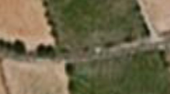
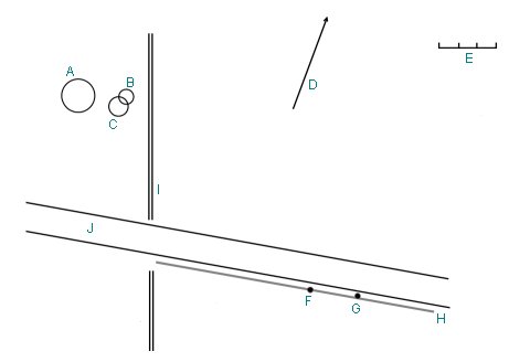
Aerial sights of the site can be found in the satellites images databases, for example via the free software Google Earth (earth.google.fr). The geographical co-ordinates of the site are 44°58'52.23" North and 2°55'20.39" East.
|
To understand the situation, some explanations must be given.
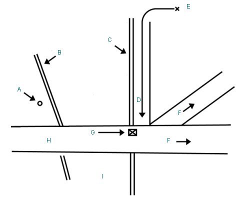
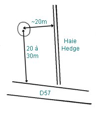
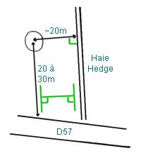
The reader must know where the GEPAN investigation locates things. Of course the "skeptical" authors consider to have proven that the location of the things in the GEPAN investigation is false and will consider false all the indications that I will give. Thus, when the GEPAN report indicates that the center of the trace was at 20 to 30 meters from the road parallel to the hedge, the "skeptical" authors consider this to be false with the reason that the road makes a definite turn. Let's just place the trace following the GEPAN indications, according to their sketch number 1 on which the values and what they relate to are explained:
|
Let's place this on the satellite picture:
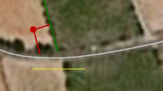
|
The yellow line is a scale, its length is 68 meters. The road is in gray, the hedge is in green, the situation of the trace and the related lines of measurements are in red.
Let's observe:
Firstly, the "definite turn" has a ridiculously weak angle. This angle becomes more marked not "before", i.e. on the right of the hedge but "after" the places, i.e. on the left on the image.
Secondly, whatever the turn, it does have absolutely no bearing on the measures. It is perfectly clear that one the of measurements, "1" on my sketch, is the distance between the edge of the road and the center of the trace parallel to the hedge, and whether the road is straight or curved changes absolutely nothing there! The road is given as one end of this distance, the hedge is used to indicate the direction. Anyone going on the location can stand at the edge of the road and walk into the field for 20 to 30 meters parallel to the hedge, it is thus an indication of the of perfectly clear nature of what was measured, and it is completely independent to the question of the road being straight or curved.
Of course, it is necessary to also know at which spot of the edge of the road one needs to stand before entering the field and to walk in parallel to the hedge for 20 to 30 meters. And that is perfectly clearly also: the distance to the hedge, orthogonal to the hedge, must be approximately 20 meters at your point of arrival; which is the center of the trace.
Sketch 1 of the GEPAN report was perfectly clear, it does not depend on any "definite turn of the road", moreover an weak angle turn actually, a portion of road which can extremely well be considered rectilinear in the circumstance, which could not involve the least error of measurement, which does not create any "inconsistency" at all about the indications of where the trace was:
|
Let's conclude on this:
If our "skeptical" authors proved to be unable to find the place of the trace center using the GEPAN instructions, it would not at all be caused by that alleged neglect of a turn in the road, but an incapacity to understand instructions despite their simplicity and clarity as anyone with a bit of common sense can see.
There is no inconsistency here, and of course, all that has no capacity to show that the placements of the trace, the witnesses, the object, its size, the size of the occupants, the departure bearing or any other measurement given in the GEPAN report would be "consequently" incoherent in any manner!
Let's continue with sketch 2, that the authors consider to prove inconsistency with the reason of a "definite turn" of the road.
This sketch number 2 sketch is as below:
|
|
|
A: Landing spot of the ball |
It is obvious that the road is of an unreasonable width, and it is obvious that no measurement of the object, the trace, or other distance or position is reproduced on this sketch.
Anyone with a bit of common sense can understand that the sketch number 1 was not to be mistaken for a topographic chart or a roadmap, and had another ambition, it was only allow the reader to locate the placement of the center of the trace. I showed that this sketch gave reliable instructions that any good sense person can follow to find it, that there was no inconsistency, no neglect of road curve bearing on the accuracy of the instructions.
Well, as of the second sketch, I think that any person of common sense can understand that this free-hand drawing is simply given so that someone reading the report and going to Cussac can find the various relevant sites.
And more specifically, this sketch is there with the only ambition to explain from where the farmer came, the farmer that the children encountered after their alleged observation, and at which crossroads they met, nothing more!
It is obvious that the ambition of the draughtsman was absolutely not to provide a topographical map here, respecting "proportions" or distances, but only to provide landmarks relating to the situation of an episode of the witnesses story!
This goal is completed perfectly besides, perhaps not for the "skeptical" authors, but at least for me:
|
Once again, there is no "inconsistency" of the least measurement.
Let's continue with sketch number 3 at page 13:
|
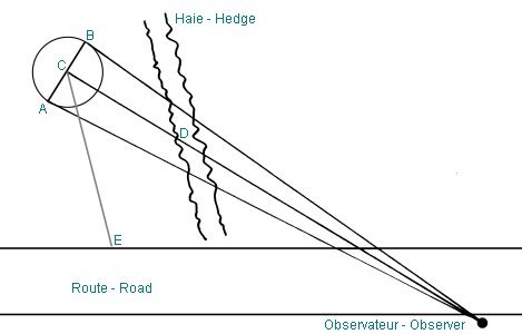
Again, this is neither about a roadmap nor of topographical map, but very obviously a figure provided so that the reader understands the significance of letterings A, B, C and E used to explain estimates made with the theodolite by the witnesses, separately, about the size of the alleged object.
In the report, for example, a "C-E distance", an "A-B distance" are given; it is obvious that an explanatory sketch about what was meant with "C-E", "A-B" etc. was necessary, and that is what the sketch is about.
Here again, there is null "inconsistency", no "error" to claim under the pretense of a road curve "definite turn" of the road.
Let's now see the sketch at page 25:
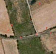
|
A: [?] of trace (yellowed grass) according to the gendarme (circle of diameter 4 to 5 meter).
B: Object position according to A.M. [the girl, witness] Diameter of 3 meters.
C: Object position according to F. [the boy, witness] Diameter of 5 meters.
D: Direction of the geographic North.
E: A scale, 5 meters between the graduations.
F: Position given by A.M. [the girl, witness]
G: Position given by F. [the boy, witness]
H: Dry stones wall.
I: Hedge
There is indeed what appears to be an error on this sketch. In paragraph 7 of the report are the data about the diameters of the three circles appearing on this sketch, these are indeed the data indicated on the sketch, namely, a circular trace of a diameter from 4 to 5 meters according to the gendarme, an object of a width of 3 meters according to the girl, an object of a width of 5 meters according to the boy.
The error that I see is that the circle A for the trace, with a diameter given as 4 to 5 meters, is drawn larger than the circle C given as 5 meters in diameter representing the object according to the boy. In fact the diameter drawn for the trace here would match to a 9.70 meters diameter trace.
But, what is interesting about this mistake is that far from "favoring the case", it introduces on the contrary, all things considered, a difference that wasn't; if one must think of the consequences of this drawing error, it does not favor but diminish the case. The drawing makes believe that the diameter of the ball according to the boy is smaller than the diameter of the trace according to the gendarme, whereas these two diameters are actually much more concordant.
The second problem with the circle of the trace is that the distance from its center compared to the edge of the road parallel to the hedge has a considerable uncertainty since this distance is "20 to 30" meters; there is thus an uncertainty of 10 meters on the situation of this center in this direction there. The distance on the sketch being of 30 meters, one can deduce that the author of the sketch chose the maximum value. It is clear that this choice, not an error but an arbitrary choice, does appear "favorable to the case" since it places the trace in a better alignment with the situations for the object; if the draughtsman had placed it 10 meters more close to the road by adopting the minimal value, this alignment would be reduced.
One can wonder what the purpose of this sketch was. It so happens that it is the only one from the four to be "detached" from the body text, to be at the end of the report as in appendix; its purpose is thus not obvious. It seems however that it was supposed to show where the witnesses stood one compared to the other, since it is an information item not given by the other sketches. It is certainly obvious that the road is traced as straight, that the hedge that crosses the road is also traced straight whereas it is not prolonged in straight line from one side of the road to the other in reality. Can we infer from it that measurements are false? I do not see why, since measurements are never made from any of the sketches, but made on the ground and explained via the sketches. Here again, the so-called "definite turn" of the road, although not shown on the sketch, in no way allows to claim any measurement false. And no measurement deferred on this diagram is false except for the diameter of the trace. I have besides the impression to be the only one to have noted that the diameter of the trace on this drawing is 9.70 meters whereas it should have been of 5 meters as indicated near it - and yet this a glitch very obvious to the eye.
For the authors, there is a "definite turn" of the road. One can wonder, when looking at a satellite picture showing a rather slight curve, of the notion of a "definite turn" even before the hedge came up.
I submit that this was only an illusion that was created from looking at photographs and sketches of views from the ground.
It is sufficient to have a look at the 1968 photograph by investigator Claude de Saint-Etienne, reproduced by the authors in their book, used for several drawings relating to the case in several other sources, to understand that indeed, there is an illusion of a sharp turn of the road, caused by perspective when seen from the ground on the road looking at in the relevant direction:
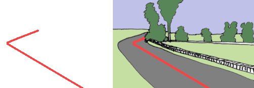
|
Normally, this type of rather classical illusion should be well-known to ufologists.
We observe, by repeating the assertions of the "skeptical" authors, listed in introduction and reminded here:
This "skeptical" argumentation is thus invalid.
| Version: | Created/changed by: | Date: | Description: |
|---|---|---|---|
| 0.1 | Patrick Gross | April 23, 2008 | Creation. |
| 1.0 | Patrick Gross | April 23, 2008 | First publication. |
| 1.1 | Patrick Gross | April 24, 2008 | I realized that on the GEPAN sketch 3, I forgot to put the caption of the point "D". I added this now. The absence of this "D", however, had no bearing on the article. |
| Date: | From: | Content: | Response: |
|---|---|---|---|
| April 23, 2008 | First publication. | ||
| - | - | - | - |