|
|
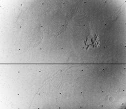
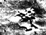
This object is named in many books and other publications as "Airport-Terminal". Not one of those sources shows the correct image ID# for finding the original data in the NASA-archives. The best reference is from David Hatcher Childress' book Extraterrestrial Archeology, where the coordinates are given: 1.9°S 186.4°W and the image-ID 4209-75.
|
Mariner 9 picture, from frame 4209-75.
|
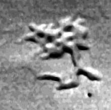
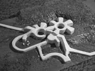
In order to better understand the structure, a model was constructed from foam and plaster. Note the rectangular "ductwork" which both enters and exits the object... could this be some sort of "pumping station" for liquid water? It would be interesting to find an MGS image of the same area!
Note, that the object is not a group of mesas rising out of the plains, as it is described in the sources named above. It is a system of trenches and elevation isolated in a flat area over about 5 x 5 km2. The whole original image streches over an area of exact 55 x 42 km2.
Some technical data about the "4209-75" image, the complete EDR Image Record:
177B1732 05450 AREA CONTAIN CRACKS OF MANY SHAPES AND SIZES B35 (RAA Text Describing Image)
| INST_NUM Instrument Number: | 1 |
|---|---|
| MTYR Measurement Time Year (GMT time of TV shutter close) | 1972 |
| MTDAY Measurement Time Day (GMT time of TV shutter close) | 41 |
| MTHR Measurement Time Hour (GMT time of TV shutter close) | 11 |
| MTMIN Measurement Time Minute (GMT time of TV shutter close) | 43 |
| MTSEC Measurement Time Second (GMT time of TV shutter close) | 26 |
| MTMIL Measurement Time Millisecond (GMT time of TV shutter close) | 386 |
| DAS_TIME Spacecraft Data Acquisition System Time (DAS time of TV shutter close) | 7938348 |
| ERTYR Earth Received Time Year | 72 |
| ERTDAY Earth Received Time Day | 41 |
| ERTHR Earth Received Time Hour | 21 |
| ERTMIN Earth Received Time Minute | 53 |
| ERTSEC Earth Received Time Second | 42 |
| ERTMIL Earth Received Time Millisecond | 312 |
| TBP Time Before Periapsis, Seconds (time from closest approach) | 854 |
| DN (typo? should be ON?) Orbit Number | NULL |
| DODSYR Date of Orbit Solution | 0 |
| DAS_SER DAS Serial Number | 0 |
| DAS_ERT DAS Earth Received Time, Approximately DAS Time of Shuttle (sic) + 5 Counts | 7938353 |
| SC_ALT Spacecraft Altitude Above Surface | 2004 |
| SP_CL_A Scan Platform Clock Angle, Degrees (cross cone angle) | 281.79 |
| SP_CO_A Scan Platform Cone Angle, Degrees (cone angle) | 120.13 |
| SP_T_A Scan Platform Twist Angle, Degrees | .11 |
| SP_IMF Scan Platform in Motion Flag | 0 |
| SC_TA Spacecraft True Anomaly Angle | 34.16 |
| SC_TV Spacecraft Trangential (sic) Velocity, KM/SEC | 3.4 |
| SC_RV Spacecraft Radial Velocity, KM/SEC | .7 |
| SLAR_5 Solar Lighting Angle For Reticle 5 (Zenith Angle of Sun at Mars Surface Corresponding to Image Point Reticle 5) (incidence angle at picture center) | 42.21 |
| SLAR_1 incidence angle at upper left (as above) | 41.69 |
| SLAR_3 incidence angle at upper right (as above) | 42.59 |
| SLAR_7 incidence angle at lower left (as above) | 41.84 |
| SLAR_9 incidence angle at lower right (as above) | 42.74 |
| SAR_9 (typo? should be PAR_5? = phase angle at center) | 59.86 |
| SAR_1 (typo? should be PAR_1? = phase angle at upper left) | 60.56 |
| SAR_3 (typo? should be PAR_3? = phase angle at upper right) | 59.15 |
| PAR_7 Phase Angle for Reticle 7 (Angle Subtended By Sun And Spacecraft at Mars Surface Corresponding to Image Point Reticle 7) | 60.57 |
| PAR_9 phase angle at lower right (as above) | 59.15 |
| PAR_5 (typo? should be VAR_5? = emission angle at center) | 25.35 |
| VAR_1 Viewing Angle For Reticle 1 (Zenith Angle of Spacecraft at Mars Surface Corresponding to Image Point Reticle 1) (emission angle at upper left) | 25.73 |
| VAR_3 emission angle at upper right (as above) | 23.84 |
| VAR_7 emission angle at lower left (as above) | 26.87 |
| VAR_9 emission angle at lower right (as above) | 25.05 |
| TRF Telemetry Received Flag | 1 |
| LR_5 Latitude of Reticle Point 5 (picture center) | -2.01 |
| LR_1 Latitude of Reticle Point 1 (upper left) | -1.88 |
| LR_3 Latitude of Reticle Point 3 (upper right) | -1.47 |
| LR_7 Latitude of Reticle Point 7 (lower left) | -2.56 |
| LR_9 Latitude of Reticle Point 9 (lower right) | -2.13 |
| LOR_5 Longitude of Reticle Point 5 (picture center) | 186.54 |
| LOR_1 Longitude of Reticle Point 1 (upper left) | 187.09 |
| LOR_3 Longitude of Reticle Point 3 (upper right) | 186.25 |
| LOR_7 Longitude of Reticle Point 7 (lower left) | 186.84 |
| LOR_9 Longitude of Reticle Point 9 (lower right) | 185.99 |
| SRR_5 Slant Range to Reticle Point 5, KM (picture center) | 2131 |
| SRR_1 slant distance/range to upper left (as above) | 2135 |
| SRR_3 slant distance/range to upper right (as above) | 2116 |
| SRR_7 slant distance/range to lower left (as above) | 2148 |
| SRR_9 slant distance/range to lower right (as above) | 2128 |
| LCFR_5 Limb Crossing Flag for Reticle 5 | 0 |
| AOA Altitude of Optic Axis, KM | -1936 |
| SRP Slant Range to Phobos, KM | 12805 |
| SRD Slant Range to Deimos, KM | 25179 |
| ASD Angular Semi-Diameter of Planet | 38.9 |
| XI Osculating Inclination | 64.03 |
| GMAP S/C Flight Path Angle | 12 |
| SLAT Latitude of Sub S/C Point (sub-spacecraft latitude) | 6 |
| SLON Longitude of Sub S/C Point (sub-spacecraft longitude) | 182 |
| STP Angle at Center of Planet Between Los and R | 9 |
| RMAG Radial Distance to Center of Planet, KM | 5391 |
| ZLAT Latitude of Subsolar Point (sub-solar latitude) | -7.14 |
| ZLON Longitude of Subsolar Point (sub-solar longitude) | 228.60 |
| SS1 Shadow Coordinate of Phobos, Latitude | 49.28 |
| SS12 Shadow Coordinate of Phobox, Longitude | -688.96 |
| SS2 Shadow Coordinate of Deimos, Latitude | 49.28 |
| SS23 Shadow Coordinate of Deimos, Longitude | -688.96 |
| PPS5 scaled pixel height/width at picture center (Projected Pixel Size of Reticle 5, KM) | 4.53 |
| PPS1 scaled pixel height/width at upper left (as above) | 4.57 |
| PPS3 scaled pixel height/width at upper right (as above) | 4.46 |
| PPS7 scaled pixel height/width at lower left (as above) | 4.60 |
| PPS9 scaled pixel height/width at lower right (as above) | 4.49 |
| PDEC5 Declination of Reticle 5, Degrees | .00 |
| PRA5 Right Ascension of Reticle 5 | .00 |
| MHA Mars Local Time (Hour Angle From Sub-Solar Point) | 14.80 |
| SUNNAN Sun Direction in Image, Degrees | 197 |
| SPANG Angle at Planet Between Sun and Los Intercept | 59 |
| SHPSV Angle at Los Between Sun and Los Intercept | 125 |
| AZPHA Tilt Azimuth, Degrees | .00 |
| RL Range to Limb, KM | 4194 |
| LATL Latitude of Left Limb Extreme | -49.28 |
| LATR Latitude of Right Limb Extreme | -49.28 |
| LATC Latitude of Center of Limb | -49.28 |
| LONR Longitude of Left Limb Extreme | -49.28 |
| LONL Longitude of Right Limb Extreme | -49.28 |
| LONG (typo? should be LONC?) Longitude of Center of Limb | -49.28 |
| NORAN Direction of North in Image Plane, Degrees (north azimuth) | 291 |
| SPL05 Angle in Picture Frame Between Sun-S/C Point and Frame Axis at Los | 320 |
| SSL05 Angle in Picture Frame Between Subsolar Point and Frame Axis at Los | 197 |
| PST05 Angle at Spacecraft Between Los and Vector to Center of Planet | 15 |
| PP1835H Picture Planet Height (picture height in km; scaled image height) | 55 |
| PP1835W Picture Planet Width (picture width in km; scaled image width) | 42 |
| MDEED Mars Date (Equivalent Earth Date), Month | 0 |
| MDAY Mars Date (Equivalent Earth Date), Day (planet day number | 0 |
| FIL_ID Filter ID (filter name) | 13 |
| FIL_MODE Filter Mode (filter number) | 0 |
| EI Exposure Interval (instrument exposure duration) | 1 |
| EM Exposure Mode (instrument mode identification) | 0 |
| CAM_ID Camera ID | 0 |
| PIC_ID Picture ID (revolution number; frame identification) | 35 |
| LINES Number of Lines in Picture | 698 |
| APV Average Pixel Value | 13 |
| VT Vidicon Temperature | 0 |
| VR1 Planet Center to Spacecraft (Vectors) (target center distance) | 2268.92 |
| VR2 Centered Earth Equatorial 1950.0 (Vectors) | -4142.54 |
| VR3 Coordinates (Vectors) | -2599.65 |
| C11 C Matrix (Column 1, Row 1) | .798210 |
| C12 C Matrix (Column 1, Row 2) | .538030 |
| C13 C Matrix (Column 1, Row 3) | .270892 |
| C21 C Matrix (Column 2, Row 1) | .052984 |
| C22 C Matrix (Column 2, Row 2) | .385252 |
| C23 C Matrix (Column 2, Row 3) | -.921288 |
| C31 C Matrix (Column 3, Row 1) | -.600043 |
| C32 C Matrix (Column 3, Row 2) | .749735 |
| C33 C Matrix (Column 3, Row 3) | .279005 |
| ISLAT ? | 6.6661 |
| RSLON ? | 182.0936 |
| SNORAN ? | 291.1638 |
| LR_2 Latitude of Reticle Point 2 | -1.67 |
| LOR_2 Longitude of Reticle Point 2 | 186.67 |
| LR_4 Latitude of Reticle Point 4 | -2.22 |
| LOR_4 Longitude of Reticle Point 4 | 186.97 |
| LR_6 Latitude of Reticle Point 6 | -1.80 |
| LOR_6 Longitude of Reticle Point 6 | 186.12 |
| LR_8 Latitude of Reticle Point 8 | -2.34 |
| LOR_8 Longitude of Reticle Point 8 | 186.41 |
| QST ? | 15.4851 |
| QLAT Latitude of Point Q, Q Point Is Near Reticle Point 5, It Is The Center of the Optic Axis | -1.9210 |
| QLON Longitude of Point Q | 186.5364 |
| QSRR_5 ? | 2131.89 |
| SRR_Q Slant Range to Point Q, KM | 2129.75 |
| QANG ? | 90.1866 |
| MEAS_ID Measurement ID (Instrument ID; TV Camera ID) | TV*B |
| SC_ID Spacecraft ID | 75 |
| OSN Orbit Solution Number | H093 |
| MDR_NUM Command Master Data Record Number | 177B1732 054 |
| EDR_NUM EDR Number | 92**EDR***** |