The Mars Global Surveyor image bewlow was released on May 22, 2000 by the Malin Space Center on its web site, hosting thousand of images and data from Mars. This is the MOC narrow-angle image M01-02950:
|
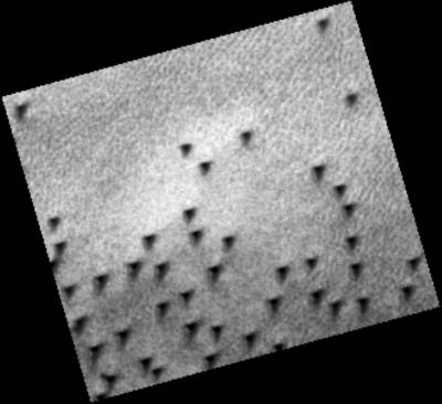
The same image, processed but NOT map-projected:
|
At this time I am simply speechless. "What is it?" is my only comment!
The fact: we have here a sort of graveyard of numerous rectangular shaped monoliths, each about 80 meters long on their apparent part, partly buried in the soil on the side of a hill.
Original location of these images and their related data at NASA web site:
www.msss.com/moc_gallery/ab1_m04/images/M0102950.html.
Let me insist that this image is an official image provided directly by the Malin Space Center, NASA's private contractor for Mars imagery of the Mars Global Surveyor satelitte orbiting Mars.
| Acquisition parameters: | |
|---|---|
| Image ID (picno): | M01-02950 |
| Image start time: | 1999-05-21T02:56:31.99 SCET |
| Image width: | 256 pixels |
| Image height: | 256 pixels |
| Line integration time: | 0.4821 millisec |
| Pixel aspect ratio: | 0.88 |
| Crosstrack summing: | 8 |
| Downtrack summing: | 8 |
| Compression type: | MOC-NONE |
| Gain mode: | 6A (hexadecimal) |
| Offset mode: | 26 (decimal) |
| Derived values: | |
| Longitude of image center: | 263.03°W |
| Latitude of image center: | 79.05°N |
| Scaled pixel width: | 12.88 meters |
| Scaled image width: | 3.31 km |
| Scaled image height: | 2.91 km |
| Solar longitude (Ls): | 141.94° |
| Local True Solar Time: | 13.53 decimal hours |
| Emission angle: | 0.33° |
| Incidence angle: | 64.77° |
| Phase angle: | 64.71° |
| North azimuth: | 105.37° |
| Sun azimuth: | 310.07° |
| Spacecraft altitude: | 433.62 km |
| Slant distance: | 433.62 km |